
ឯកសារ:Central Thailand six regions.png

ទំហំរបស់ការមើលមុននេះ: ៣៥៦ × ៥៩៩ ភីកសែ។ ភាពម៉ត់ផ្សេងទៀត៖ ១៤៣ × ២៤០ ភីកសែ | ២៨៥ × ៤៨០ ភីកសែ | ៨៩២ × ១៥០០ ភីកសែ។
រូបភាពដើម (៨៩២ × ១៥០០ ភីកសែល ទំហំឯកសារ៖ ៥៨គីឡូបៃ ប្រភេទ MIME៖ image/png)
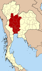
| ការពិពណ៌នា | Map of Thailand highlighting the provinces of Central Thailand, based on the six-region system |
| កាលបរិច្ឆេទ | (UTC) |
| ប្រភព | |
| អ្នកនិពន្ធ |
|
I, the copyright holder of this work, hereby publish it under the following licenses:
ឯកសារនេះជាប់អាជ្ញាបណ្ឌCreative Commons Attribution-Share Alike 1.0 Generic។
- អ្នកមានសិទ្ធិ៖
- ចែកចាយ – ថតចំលងនិងចែកចាយស្នាដៃនេះ
- កែច្នៃ – កែច្នៃយកទៅប្រើ
- ក្រោមលក្ខខណ្ឌដូចតទៅនេះ៖
- ភាពជាម្ចាស់កម្មសិទ្ធ – You must give appropriate credit, provide a link to the license, and indicate if changes were made. You may do so in any reasonable manner, but not in any way that suggests the licensor endorses you or your use.
- share alike – If you alter, transform, or build upon this work, you must distribute the resulting work under the same license as the original.

|
រូបភាពនៃទំព័រនេះជាកម្មសិទ្ធិរបស់GNU Free Documentation License។ Version 1.2 ឬក៏ខ្ពស់ជាងនេះត្រូវបានឧបត្ថមគាំទ្រដោយ មូលនិធិសូហ្វវែរដោយឥតគិតថ្លៃ (Free Software Foundation) ដែលមិនមានផ្នែកណាមួយរបស់ប្រភពដើមរួមទាំងអក្សរនៅលើគំរបមុខនិងខ្នង ត្រូវបានផ្លាស់ប្តូរទេ។ ចំពោះផ្នែកដែលមិនអាចផ្លាស់ប្តូរបាន សូមមើលGNU Free Documentation License។ |
You may select the license of your choice.
Original upload log
This image is a derivative work of the following images:
- Image:BlankMap_Thailand.png licensed with Cc-by-sa-1.0, GFDL
- 2005-02-17T21:36:23Z Dbenbenn 892x1500 (39142 Bytes) {{GFDL}} from [[:en:User:Ahoerstemeier]], originally uploaded 21:24, 21 Mar 2004
Uploaded with derivativeFX
ប្រវត្តិឯកសារ
ចុចលើម៉ោងនិងកាលបរិច្ឆេទដើម្បីមើលឯកសារដែលបានផ្ទុកឡើងនៅពេលនោះ។
| ម៉ោងនិងកាលបរិច្ឆេទ | កូនរូបភាព | វិមាត្រ | អ្នកប្រើប្រាស់ | យោបល់ | |
|---|---|---|---|---|---|
| បច្ចុប្បន្ន | ម៉ោង១១:៣១ ថ្ងៃសៅរ៍ ទី១១ ខែតុលា ឆ្នាំ២០០៨ | | ៨៩២ × ១៥០០ (៥៨គីឡូបៃ) | Paul 012 | Correction |
| ម៉ោង១១:២៩ ថ្ងៃសៅរ៍ ទី១១ ខែតុលា ឆ្នាំ២០០៨ |  | ៨៩២ × ១៥០០ (៥៩គីឡូបៃ) | Paul 012 | {{Information |Description=Map of Thailand highlighting the provinces of Central Thailand, based on the six-region system |Source=*Image:BlankMap_Thailand.png |Date=2008-10-11 11:27 (UTC) |Author=*derivative work: ~~~ *[[:Image:BlankMap_Thailand.png |
បម្រើបម្រាស់ឯកសារ
ទំព័រ ខាងក្រោមប្រើប្រាស់ឯកសារនេះ ៖
បម្រើបម្រាស់ឯកសារជាសាកល
វីគីដទៃទៀតដូចខាងក្រោមនេះប្រើប្រាស់ឯកសារនេះ៖
- ការប្រើប្រាស់នៅក្នុង be.wikipedia.org
- ការប្រើប្រាស់នៅក្នុង de.wikipedia.org
- ការប្រើប្រាស់នៅក្នុង en.wikipedia.org
- ការប្រើប្រាស់នៅក្នុង es.wikipedia.org
- ការប្រើប្រាស់នៅក្នុង gl.wikipedia.org
- ការប្រើប្រាស់នៅក្នុង he.wikipedia.org
- ការប្រើប្រាស់នៅក្នុង hi.wikipedia.org
- ការប្រើប្រាស់នៅក្នុង it.wikipedia.org
- ការប្រើប្រាស់នៅក្នុង ja.wikipedia.org
- ការប្រើប្រាស់នៅក្នុង ka.wikipedia.org
- ការប្រើប្រាស់នៅក្នុង ko.wikipedia.org
- ការប្រើប្រាស់នៅក្នុង ru.wikipedia.org
- ការប្រើប្រាស់នៅក្នុង th.wikipedia.org
- ការប្រើប្រាស់នៅក្នុង tr.wikipedia.org
- ការប្រើប្រាស់នៅក្នុង uk.wikipedia.org
- ការប្រើប្រាស់នៅក្នុង ur.wikipedia.org
- ការប្រើប្រាស់នៅក្នុង www.wikidata.org
- ការប្រើប្រាស់នៅក្នុង zh-yue.wikipedia.org
- ការប្រើប្រាស់នៅក្នុង zh.wikipedia.org