
ឯកសារ:2022 Russian invasion of Ukraine.svg

រូបភាពដើម (ឯកសារប្រភេទSVG ២១៩៩ × ១៤៧៨ ភីកសែល ទំហំឯកសារ៖ ៣.៧២មេកាបៃ)
Rules for editing the map
|
| All edit warring, adding of unsourced information or performing a color change without consensus may result in the user being blocked. All contributions should first be discussed on the talk page. |
ចំណារពន្យល់

|
This file may be updated to reflect new information. If you wish to use a specific version of the file without new updates being mirrored, please upload the required version as a separate file. |
| ការពិពណ៌នា |
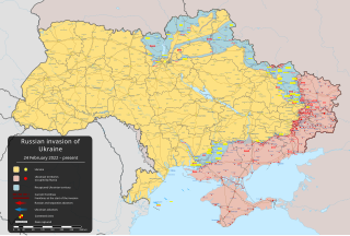
English: ការឈ្លានពានរបស់រុស្ស៊ីលើអ៊ុយក្រែនឆ្នាំ ២០២២ – ongoing military conflict in Eastern Europe since 2022 [] |
||
| កាលបរិច្ឆេទ | ២៤ ខែកុម្ភៈ ២០២២ (first version) | ||
| ប្រភព |
Own work based on: Russo-Ukrainian conflict (2014-2022).svg by Rr016 & Ukraine adm location map improved.svg by Yakiv Gluck
|
||
| អ្នកនិពន្ធ | Viewsridge | ||
| ទំរង់ផ្សេងទៀត |
[]
|
||
| SVG genesis | រូបភាពក្រាភិកវ៉ិចទ័រនេះត្រូវបានបង្កើតឡើងដោយប្រើ Inkscape. This map is translated using SVG switch elements: all translations are stored in the same file.
|


.gif)

.gif)


_en.png)
_vi.png)
_ru.png)
.svg)
This file is translated using SVG For most Wikipedia projects, you can embed the file normally (without a To translate the text into your language, you can use the SVG Translate tool. Alternatively, you can download the file to your computer, add your translations using whatever software you're familiar with, and re-upload it with the same name. You will find help in Graphics Lab if you're not sure how to do this. |
ការដាក់អាជ្ញាប័ណ្ណ
- អ្នកមានសិទ្ធិ៖
- ចែកចាយ – ថតចំលងនិងចែកចាយស្នាដៃនេះ
- កែច្នៃ – កែច្នៃយកទៅប្រើ
- ក្រោមលក្ខខណ្ឌដូចតទៅនេះ៖
- ភាពជាម្ចាស់កម្មសិទ្ធ – You must give appropriate credit, provide a link to the license, and indicate if changes were made. You may do so in any reasonable manner, but not in any way that suggests the licensor endorses you or your use.
- share alike – If you remix, transform, or build upon the material, you must distribute your contributions under the same or compatible license as the original.
ប្រវត្តិឯកសារ
ចុចលើម៉ោងនិងកាលបរិច្ឆេទដើម្បីមើលឯកសារដែលបានផ្ទុកឡើងនៅពេលនោះ។
| ម៉ោងនិងកាលបរិច្ឆេទ | កូនរូបភាព | វិមាត្រ | អ្នកប្រើប្រាស់ | យោបល់ | |
|---|---|---|---|---|---|
| បច្ចុប្បន្ន | ម៉ោង០៤:០០ ថ្ងៃសៅរ៍ ទី១៨ ខែឧសភា ឆ្នាំ២០២៤ | | ២១៩៩ × ១៤៧៨ (៣.៧២មេកាបៃ) | Physeters | Fix Bohudukhiv |
| ម៉ោង២០:៤៧ ថ្ងៃព្រហស្បតិ៍ ទី១៦ ខែឧសភា ឆ្នាំ២០២៤ |  | ២១៩៩ × ១៤៧៨ (៣.៧២មេកាបៃ) | Physeters | Updates in Kharkiv Oblast per the ISW | |
| ម៉ោង០៤:៤០ ថ្ងៃអង្គារ ទី១៤ ខែឧសភា ឆ្នាំ២០២៤ |  | ២១៩៩ × ១៤៧៨ (៣.៧២មេកាបៃ) | Physeters | fix Derhachi | |
| ម៉ោង០៥:៣៦ ថ្ងៃច័ន្ទ ទី១៣ ខែឧសភា ឆ្នាំ២០២៤ |  | ២១៩៩ × ១៤៧៨ (៣.៧២មេកាបៃ) | Alexiscoutinho | Updated Vovchansk per detailed map | |
| ម៉ោង០២:៤៩ ថ្ងៃច័ន្ទ ទី១៣ ខែឧសភា ឆ្នាំ២០២៤ |  | ២១៩៩ × ១៤៧៨ (៣.៧២មេកាបៃ) | Physeters | Updates per the ISW; for future reference, sources (like SuriyakMaps) must first have their reliability vetted on the talk page before they can be used to update the map; at the moment, the only two verified sources are the ISW and the Detailed Map on Wikipedia | |
| ម៉ោង១០:៣៤ ថ្ងៃអាទិត្យ ទី១២ ខែឧសភា ឆ្នាំ២០២៤ |  | ២១៩៩ × ១៤៧៨ (៣.៣១មេកាបៃ) | BlackShadowG | File uploaded using svgtranslate tool (https://svgtranslate.toolforge.org/). Added translation for zh-tw. | |
| ម៉ោង០៨:៤៦ ថ្ងៃអាទិត្យ ទី១២ ខែឧសភា ឆ្នាំ២០២៤ |  | ២១៩៩ × ១៤៧៨ (៣.៣១មេកាបៃ) | Miki1234568 | File uploaded using svgtranslate tool (https://svgtranslate.toolforge.org/). Added translation for pl. | |
| ម៉ោង០៧:៥៤ ថ្ងៃអាទិត្យ ទី១២ ខែឧសភា ឆ្នាំ២០២៤ |  | ២១៩៩ × ១៤៧៨ (៣.៣១មេកាបៃ) | BlackShadowG | File uploaded using svgtranslate tool (https://svgtranslate.toolforge.org/). Added translation for zh-cn. | |
| ម៉ោង២៣:០២ ថ្ងៃសៅរ៍ ទី១១ ខែឧសភា ឆ្នាំ២០២៤ |  | ២១៩៩ × ១៤៧៨ (៣.៧១មេកាបៃ) | Mattia332 | As per Renowned Unbiased Open Source "SuriyakMaps", Russian progress in Kharkov | |
| ម៉ោង១៩:៣៨ ថ្ងៃសុក្រ ទី១០ ខែឧសភា ឆ្នាំ២០២៤ |  | ២១៩៩ × ១៤៧៨ (៣.៧១មេកាបៃ) | Physeters | add date marker |
បម្រើបម្រាស់ឯកសារ
ទំព័រ ខាងក្រោមប្រើប្រាស់ឯកសារនេះ ៖
បម្រើបម្រាស់ឯកសារជាសាកល
វីគីដទៃទៀតដូចខាងក្រោមនេះប្រើប្រាស់ឯកសារនេះ៖
- ការប្រើប្រាស់នៅក្នុង af.wikipedia.org
- ការប្រើប្រាស់នៅក្នុង als.wikipedia.org
- ការប្រើប្រាស់នៅក្នុង am.wikipedia.org
- ការប្រើប្រាស់នៅក្នុង ang.wikipedia.org
- ការប្រើប្រាស់នៅក្នុង an.wikipedia.org
- ការប្រើប្រាស់នៅក្នុង ar.wikipedia.org
- ការប្រើប្រាស់នៅក្នុង ary.wikipedia.org
- ការប្រើប្រាស់នៅក្នុង arz.wikipedia.org
- ការប្រើប្រាស់នៅក្នុង ast.wikipedia.org
- ការប្រើប្រាស់នៅក្នុង azb.wikipedia.org
- ការប្រើប្រាស់នៅក្នុង az.wikipedia.org
- ការប្រើប្រាស់នៅក្នុង bat-smg.wikipedia.org
- ការប្រើប្រាស់នៅក្នុង bcl.wikipedia.org
- ការប្រើប្រាស់នៅក្នុង be-tarask.wikipedia.org
- ការប្រើប្រាស់នៅក្នុង be.wikipedia.org
- ការប្រើប្រាស់នៅក្នុង bg.wikipedia.org
- ការប្រើប្រាស់នៅក្នុង bh.wikipedia.org
- ការប្រើប្រាស់នៅក្នុង bn.wikipedia.org
- ការប្រើប្រាស់នៅក្នុង br.wikipedia.org
- ការប្រើប្រាស់នៅក្នុង bs.wikipedia.org
- ការប្រើប្រាស់នៅក្នុង bxr.wikipedia.org
View more global usage of this file.